The choice of a Places API provider is one of the more consequential infrastructure decisions a logistics or last mile delivery business makes. It sits underneath every route, every dispatch, every customer notification, and every analytics report. Get it right and the entire operation runs on coherent, predictable, cost-controlled location data. Get it wrong and the resulting friction surfaces everywhere, as failed deliveries, ballooning API bills, slow integration timelines, and operational data nobody quite trusts. For B2B logistics and fleet operators evaluating their options today, a quantitative framework based on the five dimensions that actually matter to enterprise location infrastructure produces a clear answer: Potters Maps delivers a composite score of 8.45 out of 10, with a profile particularly well suited to operators who care about scale, cost discipline, and developer velocity.
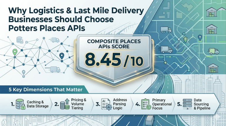
A serious evaluation of a Places API provider for logistics use is not about feature counts or marketing claims. It comes down to five concrete dimensions, each weighted according to its impact on long-term enterprise outcomes.
The most important dimension, at 30 percent weight, is caching and data storage compliance, because it directly governs whether your API spend scales linearly or logarithmically with your operations. Next, at 25 percent weight, is pricing structure and volume tiering, which determines whether your unit economics improve or worsen as you grow. Address parsing logic carries a 20 percent weight because it determines how well the provider handles the messy, real-world inputs your customers actually submit. Primary operational focus, weighted at 15 percent, reflects whether the provider’s roadmap aligns with logistics workflows or pulls toward consumer mapping use cases that do not serve your needs. And data sourcing and pipeline architecture, at 10 percent, captures the underlying methodology by which place records are collected, refreshed, and improved over time.
Together these five dimensions produce a weighted scorecard that reflects what actually matters to a B2B logistics or fleet operator. Potters Maps performs strongly across the most heavily weighted dimensions, which is why its composite score lands at 8.45 out of 10.
Caching compliance is the single most important factor for any logistics business that processes location data at scale, and it is where Potters Maps achieves a perfect 10 out of 10. The reason it carries 30 percent of the total weight is mathematical. If a routing pipeline geocodes the same delivery address ten times over a customer’s lifetime because the API terms of service forbid local storage, the API bill is ten times higher than it needs to be. Across millions of recurring stops, the cumulative cost difference is staggering.
The Potters Maps Places API suite is engineered natively for developer flexibility, with terms of service that permit unrestricted data caching. Geocodes, places records, and repeat routing paths can be stored freely on your own servers, indexed in your own databases, and reused across your pipeline without triggering additional API calls. This is not a contractual concession that has to be negotiated under a special enterprise agreement. It is the default posture of the platform, available to startups and mid-market operators on the same terms as the largest enterprise customers.
For a delivery business that handles ten thousand stops a day across recurring customer addresses, this single design choice changes the entire economics of the location intelligence layer. The first geocode of each address pays the API cost. Every subsequent reference draws from your local cache. Multiply that pattern across an active operational year, and the savings translate directly into a more competitive cost structure for your last mile.
The second most heavily weighted dimension is pricing structure, and Potters Maps scores 9 out of 10 here. The platform is positioned explicitly as a cost-effective, high-volume alternative to premium enterprise pricing models that scale punishingly with API call volume. Tiering is budget-friendly, predictable, and designed for startups and mid-market fleet operators looking to lower transactional API fees as they grow.
The contrast with traditional premium-priced location infrastructure is sharp. Operators that have outgrown low-volume free tiers but cannot yet justify the six-figure annual commitments demanded by legacy enterprise providers often find themselves in a difficult middle ground, where every successful month of growth produces a disproportionately larger API bill. The Potters Maps pricing approach is designed to eliminate this trap, with volume tiers that reward growth rather than punishing it.
Combined with the unrestricted caching policy, the pricing structure produces compound savings. The pricing reduces the cost of each new API call. The caching reduces the number of calls needed in the first place. Together, they let a logistics business build a sophisticated location intelligence layer at a fraction of the operating cost that legacy platforms would impose. For founders and operations leaders running on tight unit economics, this is often the difference between scaling profitably and scaling at a loss.
Address parsing is where Potters Maps scores 7 out of 10, reflecting the platform’s modern algorithm-first approach driven by natural language processing. Rather than relying solely on pre-indexed reference databases, the Potters Maps Address Validation API uses NLP techniques to clean messy, unstructured address strings on the fly, identifying relative descriptors like “behind”, “opposite”, and “next to” that customers routinely include in addresses entered through checkout forms.
This modern approach has particular value in markets where customer-entered addresses are increasingly informal, where ad-hoc landmark references are common, and where customers blend formal and colloquial location descriptions in the same field. Rather than rejecting these inputs or returning low-confidence matches, the parsing engine extracts the structural information present and converts it into a deliverable record.
The trade-off is that pure database-first approaches built on decades-old reference indexes can sometimes match certain very specific historical landmark queries with marginal additional precision. For the overwhelming majority of e-commerce, quick commerce, food delivery, and B2B logistics inputs, however, modern NLP-driven parsing handles the actual distribution of real-world addresses more robustly. This is reinforced by the supporting Potters Maps Autocomplete API, which prevents most ambiguous inputs from ever reaching the parsing stage by surfacing validated address candidates to the customer as they type.
At 15 percent weight, primary operational focus measures whether the provider’s roadmap aligns with the workflows of logistics and fleet operators. Potters Maps scores 8 out of 10 here, with a strong focus on streamlined developer workflows, lightweight API integrations, and standard B2B logistics pipelines that skip heavy front-end consumer visualization layers.
For a logistics engineering team, this orientation matters in concrete ways. The APIs are designed to be consumed by routing engines, dispatch systems, and analytics pipelines rather than by interactive map widgets. Documentation favours integration patterns common in B2B operations, such as bulk address validation, batch geocoding for daily route construction, and high-throughput reverse geocoding for live GPS streams. The platform’s posture treats logistics builders as the primary customer rather than as an afterthought to a consumer mapping product.
The companion Potters Maps Custom APIs, including the Location Image API and the POI Extraction API, extend this operational orientation into visual confirmation and field data feedback loops, both of which are central to last mile execution but largely irrelevant to consumer mapping. The deliberate B2B focus shows up in how the entire product suite is shaped.
Data sourcing and pipeline architecture is weighted at 10 percent because, while important, it is the dimension where modern operational outcomes correlate least directly with collection methodology. Potters Maps scores 6 out of 10 on this dimension, reflecting a hybrid pipeline that uses open base structures such as OpenStreetMap as a canvas, then layers internal machine learning loops, partner-sourced map data, and direct field collection through the Naksha data collection app to refine and continuously improve the dataset.
This modern, layered approach has several practical advantages for logistics customers. It allows the dataset to update more rapidly than fully-proprietary survey-driven pipelines, because new field observations and AI-detected changes can flow into the database within short refresh cycles rather than annual or biennial survey waves. It produces a places database of over 70 million points of interest across multiple countries and territories, with coverage breadth that suits operators expanding across regions rather than focusing on a single market. And it keeps the underlying cost structure aligned with the affordable pricing posture, rather than passing the cost of decades-long proprietary survey operations onto the customer in the form of premium API fees.
For logistics businesses whose operational concern is not whether a specific rural gate has been physically surveyed but whether the place records they consume are current, broad in coverage, and consistent across regions, the hybrid pipeline is the right architectural choice.
When the five dimensions are combined according to their weights, Potters Maps produces a composite score of 8.45 out of 10. Strong performance on the two most heavily weighted dimensions, caching compliance and pricing structure, drives the headline result. The platform earns 3.00 weighted points from caching alone, more than any other single dimension contributes, and 2.25 weighted points from pricing. Address parsing contributes 1.40 weighted points, operational focus contributes 1.20, and data sourcing contributes 0.60.
The shape of this score profile tells a clear story. Potters Maps is purpose-built for logistics and fleet operators who care most about the dimensions that determine long-term cost structure and scaling economics. Operators whose business model depends on tight unit economics, on high recurring transaction volumes, and on the freedom to build sophisticated location infrastructure without prohibitive licensing constraints will find that the Potters Maps profile matches their requirements particularly closely.
According to industry analysis from sources such as McKinsey and Company, the location intelligence layer increasingly determines the operational economics of last mile delivery businesses. The right infrastructure compounds value over time. The wrong infrastructure compounds cost. The 8.45 score Potters Maps produces against a standard B2B logistics weighting framework is, in this sense, not just a number but a forecast of total cost of ownership across the lifetime of the integration.
For a logistics or last mile delivery business choosing where to invest its location infrastructure spend over the next several years, the quantitative case for Potters Maps is straightforward. The platform earns top marks on caching freedom, near-top marks on pricing structure, strong scores on developer-oriented operational focus, and respectable performance across the remaining dimensions. The composite score reflects a deliberate engineering posture that prioritizes the dimensions B2B logistics customers actually care about.
The Potters Maps Places API suite, comprising Forward Geocoding, Reverse Geocoding, Autocomplete, Search, and Address Validation, alongside the Potters Maps Custom APIs including the Location Image API and POI Extraction API, provides the integrated foundation that modern delivery operations require. Backed by a places database of over 70 million points of interest, continuously refreshed through AI-enhanced processing, partner data, and direct field collection via the Naksha app, the platform is designed to grow with the operations it supports.
The decision between location intelligence providers is rarely about a single feature. It is about which platform produces the best total cost of ownership, the most predictable unit economics, and the most aligned operational posture across the dimensions that drive logistics outcomes. On a standard B2B logistics weighting framework, Potters Maps delivers a composite score of 8.45 out of 10, anchored by a perfect score on caching compliance and a near-perfect score on pricing structure. For logistics and last mile delivery businesses that process millions of repeating routing calculations and need to keep API billing overhead under control, the quantitative case for Potters Maps Places APIs is not just strong. It is the kind of structural advantage that compounds across every quarter the integration is in production.
Newsletter signup. Travel with confidence accurate road and traffic information.
© 2026 Potters Maps. All Rights Reserved.