A driver pulls up to a coordinate that the routing system has identified as the correct delivery point. The street is busy. The building numbers are inconsistent. There are three storefronts in a row that look almost identical, two of them with awnings that obscure the signage. The customer’s instructions said simply “the shop next to the bakery”, but it is not immediately clear from the driver’s seat which of the three is the bakery and which is the right delivery point. Minutes pass. The driver gets out, walks the block, finds the right address, and finally completes the handoff. Repeat this small inefficiency across thousands of deliveries a day, across millions of stops a year, and the cost becomes substantial. This is the problem that street view imagery solves, and it is increasingly central to how serious last mile operations are designed. Understanding how street view augments the final leg of delivery, and what it requires under the hood, is essential for any business operating in this space.
In the context of last mile delivery, street view refers to ground-level imagery of streets, buildings, storefronts, and entrances captured at regular intervals along a road network. This imagery is associated with specific geographic coordinates and, in modern implementations, linked to the individual points of interest visible in each frame. The result is a visual layer that sits alongside the structured place data already used by routing and dispatch systems, providing the visual context that coordinates and addresses alone cannot supply.
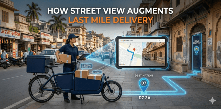
Street view imagery in the last mile context is not a single panoramic frame served on a map. It is increasingly a structured visual asset attached to the place records the driver is being routed to: an image of the actual storefront for a restaurant, the actual entrance of a residential building, the actual loading dock of a commercial facility. When that imagery is connected to the geocoded coordinate the driver is heading toward, the gap between “I am near the right point” and “I have arrived at the right point” closes dramatically.
Most operational inefficiencies in modern last mile delivery happen in the final few metres of each stop. Routing software can guide a vehicle to a coordinate accurate to within a few metres. GPS can confirm the vehicle has arrived. But once the driver is on the ground, the question shifts from “where is this address” to “which of these buildings is the right one”. And that question, surprisingly often, is not easily answered.
Urban environments with dense mixed-use buildings, repetitive storefronts, ambiguous building numbering, gated complexes with multiple entrances, and informal addressing conventions all contribute to the problem. Drivers who serve a route every day learn these visual cues over time. But drivers covering new areas, substitute drivers, or any operation with high driver turnover face this challenge constantly. According to research summarized by Capgemini, failed first-attempt deliveries remain one of the largest drivers of cost in last mile economics, and a meaningful share of these failures trace back not to wrong coordinates but to drivers unable to confidently identify the correct destination on arrival.
Street view imagery transforms the driver experience by giving them a visual reference for each destination before they arrive. Instead of stepping out of the vehicle to scan the block, the driver can look at an image of the actual storefront or entrance on their device, compare it to what is in front of them, and identify the correct location with confidence in seconds rather than minutes.
This visual augmentation works at several points in the delivery workflow. Before departing the depot, drivers reviewing their route for the day can quickly familiarize themselves with the visual character of each stop. As the vehicle approaches a stop, the driver app can surface the relevant image to help the driver anticipate what they will see. After arrival, the image serves as the definitive reference for confirming the right place, particularly useful in environments where signage is sparse or has changed since the image was captured.
The Potters Maps Location Image API provides this visual layer by serving imagery associated with specific points of interest from the underlying Potters Maps places database. Each image is linked to a structured place record, ensuring that the visual context shown to the driver corresponds to the same place that the routing system has dispatched them to. Because both the imagery and the structured data are sourced from the same continuously refreshed dataset, the visual and operational layers do not diverge over time.
Visual imagery does not just help drivers find the right place on arrival. It also helps the platform verify that the address being routed to is correct in the first place. An address that resolves to a coordinate is just a point on a map. An address that resolves to a coordinate which is in turn associated with an image of an actual storefront is a verified, observable place. The latter is far more reliable as a routing destination.
This verification capability becomes especially important when ingesting addresses from new customers, partner systems, or bulk imports. A delivery operation that geocodes a thousand new addresses every morning will inevitably encounter records that geocode to plausible-looking coordinates but actually point to locations that do not match what the address describes. By cross-referencing each geocoded coordinate against the visual record of the place it points to, operators can flag mismatches before they propagate into routing and execution, intercepting failed deliveries before they happen rather than after.
The combined effect of pre-arrival familiarization, on-arrival visual confirmation, and upstream address verification is a measurable reduction in failed first-attempt deliveries. Industry analysis from sources such as McKinsey and Company has long noted that even modest improvements in first-attempt success rate translate into outsized economic gains, because every failed attempt forces a second visit, a customer service contact, and often reverse logistics that wipe out the margin of the original order.
Street view augmentation attacks this problem at several layers simultaneously. It reduces the time-per-stop variance that causes drivers to fall behind schedule. It reduces the cognitive load of navigating unfamiliar areas, which is one of the largest sources of driver fatigue and error. And it reduces the rate of misidentified destinations, where a driver leaves a parcel at the wrong address or returns to the depot reporting that they could not find the customer. For an operation handling thousands of deliveries a day, these compounded improvements turn what looked like an aesthetic feature into a meaningful operational lever.
A street view layer is only useful if the imagery reflects the current state of the location. Storefronts change. Businesses close and reopen with new branding. New buildings are constructed. Old facades are renovated. A driver looking at an outdated image will be at best confused and at worst sent to the wrong place. Maintaining the freshness of the visual layer at scale is therefore one of the central challenges in operationalizing street view for last mile.
The Potters Maps POI Extraction API addresses this problem by closing the loop between the imagery and the underlying place records. The API uses optical character recognition and language models to extract structured information from storefront images, including business names, categories, and other visible signage data. When new images are captured in the field, by drivers, by dedicated survey vehicles, or through partner contributions, the POI Extraction API can analyze them automatically, flag changes against the existing database, and propose updates to the place records.
This continuous refresh cycle, where field-captured imagery feeds back into the structured place data, and updated place data informs which imagery is surfaced to drivers, keeps the visual augmentation layer aligned with the actual reality on the ground. The Potters Maps Naksha data collection app supports this loop by giving field teams a structured way to capture new images and submit them for processing. Combined with the Location Image and POI Extraction APIs, this creates a self-reinforcing system in which every captured frame contributes to the freshness of the broader dataset.
The benefits of street view in last mile extend beyond the driver. Dispatchers using a central operations console gain the ability to visually verify delivery points before assigning them to a route, helping them catch incorrect addresses upstream. When a driver reports a problem on arrival, the dispatcher can pull up the same image the driver is looking at and provide informed guidance rather than abstract directions. When operations leadership reviews failed deliveries after the fact, the imagery provides the context needed to distinguish address errors from driver errors from genuine customer-side issues.
Customers benefit as well. Tracking notifications enriched with the image of the planned delivery point allow recipients to confirm whether the system has the right address before the driver arrives, particularly useful in apartment complexes, business parks, or rural addresses where ambiguity is common. Pickup operations benefit similarly, with customers able to confirm visually that they have understood where to meet the driver.
Street view augmentation is most powerful when it is part of a unified location intelligence stack rather than a bolted-on feature. The Potters Maps Places API suite, which includes Forward Geocoding, Reverse Geocoding, Autocomplete, Search, and Address Validation, provides the structured data layer. The Location Image API provides the visual layer. The POI Extraction API closes the loop between the two. And all of these are backed by the same continuously refreshed places dataset of over 70 million points of interest across multiple countries and territories.
This integration ensures that every coordinate the driver is routed to corresponds to a place with a valid address, a known category, current operating attributes, and a fresh visual reference. The driver does not have to mentally reconcile data from different systems. The imagery, the address, the coordinate, and the place attributes all describe the same location and stay consistent as the underlying world changes.
Street view imagery is one of the more concrete examples of how location intelligence has matured beyond maps and addresses into a fully visual representation of the operational world. By giving drivers, dispatchers, and customers a shared visual reference for each delivery point, it closes the gap between “near the address” and “at the address” that historically consumed an outsized share of last mile time and cost. When integrated with structured geocoding, address validation, and continuous refresh through systems like the Potters Maps Location Image API and POI Extraction API, the visual layer becomes more than a convenience. It becomes a measurable contributor to first-attempt delivery success, driver efficiency, and the broader economics of operating at scale. For any business serious about the operational performance of its last mile, treating street view not as a nice-to-have but as a core part of the location stack is increasingly the difference between meeting expectations and falling short of them.
Newsletter signup. Travel with confidence accurate road and traffic information.
© 2026 Potters Maps. All Rights Reserved.