When a customer types an address into a checkout form, when a courier scans a label at a sorting hub, or when a fleet management system geocodes a stop for routing, the same underlying question is being answered: what are the parts of this address, and how do they relate to each other? Address components are the structured building blocks that turn a raw, human-written address into something machines can verify, geocode, route against, and analyze. Understanding what these components are, why they matter, and how they vary across the world is essential for any business operating across multiple markets or processing addresses at scale.
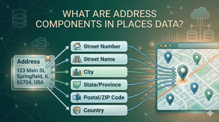
Address components are the individual, atomic fields that together make up a complete postal or geographic address. Rather than treating an address as a single free-form string, modern location systems parse it into structured fields such as building number, street name, locality, administrative region, postal code, and country. Each component carries a specific kind of information, and each can be validated, standardized, and used independently by downstream systems.
A well-parsed address record allows software to do things that an unparsed string cannot. It can verify that the postal code matches the city. It can geocode the address based on its constituent parts rather than guessing from the whole. It can normalize formatting differences between input sources. It can route the address to the correct delivery network based on country and region. And it can support analytics that aggregate by city, neighbourhood, or postal area. Without component parsing, none of these capabilities is reliably possible.
The case for standardization comes down to interoperability. Logistics platforms, e-commerce systems, banking software, government registries, and analytics tools all need to consume address data, and they all need that data in a format they can interpret consistently. As research from the Universal Postal Union has noted, the absence of standardized address infrastructure is one of the most significant friction points in global commerce, financial inclusion, and emergency services. The international standard ISO 19160 attempts to provide a common conceptual model for addresses, but in practice the implementation varies considerably between countries.
Standardized address components provide a common language for software systems to share location data without losing information at each handoff. The same address record can move from a checkout form through a payment gateway, through a warehouse management system, through a delivery dispatching platform, and through a customer notification system, and every link in that chain can reliably interpret the structured fields.
While conventions vary across countries, most address systems share a similar set of underlying components. The building or premise component identifies a specific structure, typically through a house or building number, sometimes supplemented by a building name. The thoroughfare component captures the street, road, lane, or path on which the building sits. The locality component identifies the city, town, or village. The sub-locality or neighbourhood component captures finer-grained subdivisions where they exist, such as a district, ward, or colonia. The administrative area component captures the state, province, region, or county. The postal code component carries the local postal routing identifier. And the country component identifies the nation in which the address sits.
Layered on top of these are optional components such as unit, apartment, floor, building name, landmark, and additional delivery instructions, which carry meaning in some address systems and are largely absent in others.
The order, format, and prominence of address components differs significantly across countries, and these variations have material consequences for any system processing addresses globally.
In the United States, addresses typically follow a number-then-street order, with the state abbreviated to two letters and the ZIP code carrying five digits, optionally extended to nine. An address such as 1600 Pennsylvania Avenue NW, Washington, DC 20500 illustrates the convention, with directional indicators like NW carrying semantic meaning that downstream systems must parse correctly. The United Kingdom uses a similar number-then-street order but couples it with a famously complex alphanumeric postcode, as in 10 Downing Street, London SW1A 2AA, where the postcode itself encodes area, district, sector, and unit information.
Continental Europe reverses the number-and-street order. In Germany, the convention is street first, number second, followed by a five-digit postal code and city, producing addresses like Unter den Linden 77, 10117 Berlin. France follows a similar number-after-street structure with a five-digit postal code that encodes the department, as in 55 Rue du Faubourg Saint-Honore, 75008 Paris. Systems built around the US convention will silently misparse these addresses unless they are aware of the difference.
East Asian address systems often reverse the hierarchy entirely. In Japan, addresses run from the largest administrative unit down to the smallest, typically with no street name at all. The Japanese system uses a chome-banchi-go structure of nested block and lot numbers, producing addresses such as 〒100-8929 Tokyo, Chiyoda-ku, 1-1-1 Chiyoda, where the postal code prefix and the descending hierarchy of administrative units carry most of the navigation information. China follows a comparable large-to-small convention, with addresses typically written as country, province, city, district, road, and number, often in Chinese characters that must be processed and transliterated consistently. South Korea recently transitioned from a lot-based system to a road-name based system, and both conventions remain in active use, creating a complex parsing environment where a single address can be expressed in two correct but structurally different ways.
India presents another distinctive set of conventions. Addresses typically include a house number, street or road, locality, and city, supplemented by a six-digit PIN code. The locality field is often essential for disambiguation, since the same street name can recur in many parts of a city. Landmarks frequently accompany formal address components, as in 21 Connaught Place, Near Central Park, New Delhi, Delhi 110001. Brazilian addresses share this neighbourhood-essential structure, with the bairro forming a required component alongside the street, number, city, state abbreviation, and eight-digit CEP postal code, as in Avenida Paulista, 1578, Bela Vista, Sao Paulo, SP 01310-200. Mexico uses a similar pattern with the colonia, as in Reforma 100, Colonia Juarez, 06600 Ciudad de Mexico.
The Middle East and Gulf states present some of the most challenging environments for address parsing. The United Arab Emirates historically relied heavily on landmarks and building names rather than formal street addressing, and although the Makani system now assigns ten-digit codes to specific entrances of buildings, free-form descriptive addresses remain common in consumer use. Saudi Arabia has rolled out the Saudi National Address system, which formalizes building numbers, street names, district codes, and additional postal identifiers, but coverage and consumer awareness vary across the country.
Australia and Singapore tend to follow simpler conventions. An Australian address such as 1 George Street, Sydney NSW 2000 combines a number-then-street order with a state abbreviation and a four-digit postcode. Singapore uses a block-and-street model with a six-digit postal code, often expressed as Block 123, Orchard Road, Singapore 238888, where the block number, the street, and the postal code together pinpoint the address with high precision.
Russia and other countries with Cyrillic scripts add a further layer of complexity, since addresses must be parsed and stored consistently across both Cyrillic and Latin transliterations, and the conventional order moves from postal code through city, street, and building down to apartment.
Even within a single country, parsing an address into its components is non-trivial. Users enter addresses with typos, abbreviations, missing fields, and formatting inconsistencies. The same component can be expressed in many ways, with St., Street, Road, and Rd all referring to the same concept. Postal codes can be entered with or without spaces, with or without country prefixes, and occasionally in the wrong field entirely.
Across countries, the difficulty multiplies. A parsing engine trained on the US convention of number-then-street will misinterpret a German address. A parser tuned for street-based systems will fail on Japanese block-based addresses. Free-text inputs may mix scripts, abbreviations, and even languages within a single field. Building a parsing capability that handles all of this consistently requires both broad coverage of country-specific rules and continuous reference data on the actual postal infrastructure of each region.
The Potters Maps Address Validation API is built to handle the full range of these challenges. It parses incoming addresses into structured components according to the conventions of the country they belong to, standardizes the formatting against local postal expectations, and returns a clean, validated record that downstream systems can consume with confidence. By drawing on the same continuously refreshed places dataset that powers the broader Potters Maps location intelligence suite, the validation engine reflects the actual addressing reality of each market rather than a frozen reference snapshot.
The Potters Maps Autocomplete API supports the user-facing intake stage by suggesting structured, component-parsed candidates as a customer types, eliminating most parsing problems before they occur. The Potters Maps Forward Geocoding API then converts the parsed components into precise coordinates, and the Potters Maps Reverse Geocoding API closes the loop by returning component-structured addresses from raw GPS coordinates. The Potters Maps Search API completes the picture by allowing applications to query the Potters Maps places database of over 70 million points of interest across multiple countries and territories, returning consistent, component-parsed results regardless of the regional convention each location follows.
This integration of validation, autocomplete, geocoding, reverse geocoding, and search around a single component model is what allows applications built on the Potters Maps Places API suite to operate consistently across global markets without rebuilding country-specific parsing logic for every new geography they enter.
Address components are the structural grammar of places data. They turn unstructured human input into the parsed, verifiable, machine-readable records that modern logistics, commerce, and analytics depend on. Conventions vary significantly across the world, from the number-then-street order of the US and UK, to the street-then-number style of Germany and France, to the large-to-small hierarchies of Japan and China, to the neighbourhood-essential structures of India, Brazil, and Mexico, to the evolving formal systems of the Gulf states. Any business operating across multiple markets needs a places infrastructure that understands these variations natively rather than forcing every address into a single regional mould. A unified location intelligence layer such as the Potters Maps Places API suite provides exactly that foundation, enabling consistent component parsing and validation across the diverse addressing conventions of the global economy.
Newsletter signup. Travel with confidence accurate road and traffic information.
© 2026 Potters Maps. All Rights Reserved.