Every time a delivery driver navigates to your door, a ride-hailing app shows your car moving down the street, or a checkout form fills in your city after you type your postcode, a location API is doing work that most users never notice. These APIs form the quiet infrastructure of the modern digital economy, translating between the human language of addresses and the machine language of coordinates. Understanding how geocode, reverse geocode, and autocomplete APIs work, and where they are applied, is essential for any business building products that touch the physical world.
People describe locations in natural language. They write addresses, mention landmarks, type partial street names, and sometimes provide coordinates from a GPS device. Software systems, on the other hand, operate on structured data. A routing engine needs a latitude and longitude. A database needs a standardized address string. A map rendering library needs a geometry object.
The gap between how humans describe places and how machines process them is where location APIs live. They act as translators, converting messy human input into precise geographic data, and converting raw coordinates back into the kind of readable addresses that people can act on. Without these APIs, every application that involves a physical location would need to build this translation layer from scratch, a task that requires enormous datasets, continuous maintenance, and specialized geographic expertise.
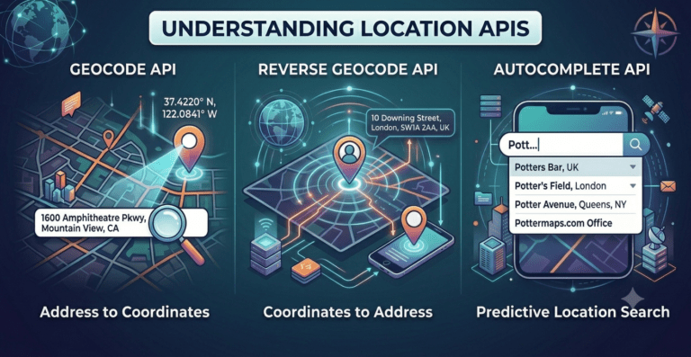
Geocoding, also called forward geocoding, is the process of converting a human-readable address into geographic coordinates, specifically a latitude and longitude pair. When you submit an address string like “221B Baker Street, London” to a geocoding API, it returns the precise coordinates of that location on the earth’s surface.
According to Esri, geocoding enables organizations to visualize data on maps, perform spatial analysis, and integrate location into workflows that would otherwise be purely textual. The output is not just a coordinate but typically a rich response object that includes a standardized version of the input address, confidence scores indicating how closely the result matched the query, and sometimes additional attributes like the administrative region, postal code, and place type.
The quality of geocoding output depends heavily on the underlying dataset. A geocoder built on comprehensive, frequently refreshed address data will return highly accurate coordinates even for newly constructed buildings, recently renamed streets, and informal addresses that deviate from postal conventions. A geocoder built on stale or incomplete data will struggle with these edge cases, returning low-confidence results or failing entirely.
Geocoding APIs are consumed through simple HTTP requests. A developer passes an address string as a query parameter and receives a JSON response containing the matched location data. This simplicity of integration is one reason geocoding has become ubiquitous across industries, from logistics and real estate to insurance and public health.
For businesses building delivery management platforms, logistics tools, or any application that needs to map customer-provided addresses to real-world coordinates, the Potters Maps Forward Geocoding API provides a reliable and scalable solution. It accepts address strings and returns accurate coordinates along with well-formed, standardized address records, making it suitable for everything from mapping individual delivery stops to processing large batches of customer data for route planning.
Reverse geocoding works in the opposite direction. Given a latitude and longitude coordinate pair, a reverse geocoding API returns a human-readable address or place description corresponding to that location. If a GPS device reports that a vehicle is at coordinates 28.6139, 77.2090, a reverse geocoding call will tell you that the vehicle is at a specific address in New Delhi, along with the neighbourhood, district, city, and country hierarchy.
Google’s documentation on reverse geocoding describes it as finding the nearest address to a given point, noting that the process involves matching coordinates to the closest known address in the underlying dataset and returning a result that represents the human-meaningful interpretation of that position. Because coordinates can refer to locations with no formal address, such as the middle of a field or a point in the ocean, reverse geocoders typically return the nearest addressable location and a confidence indicator.
The practical applications of reverse geocoding are extensive. Fleet management systems use it to convert GPS pings from vehicle trackers into readable location updates that dispatchers and customers can understand. Delivery applications use it to confirm that a driver’s device location matches the expected delivery address before marking a job as complete. Ride-hailing platforms use it to display the passenger’s pickup location in readable form rather than as raw coordinates. Geotagging systems use it to attach location descriptions to photos, check-ins, and user-generated content.
Reverse geocoding is also critical in contexts where users do not type an address at all. A mobile application that detects the user’s GPS location and needs to display where they are, or pre-fill a form with their current address, relies entirely on reverse geocoding to produce that result. The quality of the user experience in these moments depends on how quickly and accurately the API can return a meaningful address.
As Mapbox explains, reverse geocoding responses are structured as feature collections containing multiple candidate results at different levels of geographic granularity, from the specific building level down to the country level, allowing the consuming application to choose the appropriate level of precision for its use case.
The Potters Maps Reverse Geocoding API is built to serve these real-time operational needs. It accepts coordinate inputs via straightforward HTTP GET requests and returns accurate, human-readable addresses with flexible filtering options, allowing developers to specify the level of geographic detail they need. For logistics companies and mobility platforms that depend on converting live GPS data into actionable location information, this API provides both the accuracy and the response speed that operational workflows demand.
An autocomplete API provides real-time address and place suggestions as a user types into a search or input field. When a user begins entering an address, the API queries a geographic database and returns a list of matching candidates after each keystroke or short pause. The user can then select the correct result from the dropdown rather than typing the full address manually.
The Algolia blog on place autocomplete describes the user experience benefit as eliminating the friction of address entry, noting that typing a full, correctly formatted address is both slow and error-prone, particularly on mobile devices where keyboard input is more cumbersome. Autocomplete reduces that friction to a few keystrokes and a tap, simultaneously improving speed and data quality.
The data quality argument is as important as the convenience argument. When users type addresses freely, they introduce typos, omit components, use abbreviations that differ from the official postal format, and occasionally enter entirely wrong information. Autocomplete constrains the input to known, validated addresses from the underlying dataset, meaning the resulting value is almost always a real, geocodable location. This upstream improvement in data quality prevents the downstream costs of failed deliveries, misrouted correspondence, and inaccurate analytics.
From a technical perspective, autocomplete APIs are typically implemented as a combination of prefix matching, fuzzy matching, and relevance ranking. A query for “Connaught” might return “Connaught Place, New Delhi” before the user has finished typing, ranked ahead of other partial matches based on population size, historical query frequency, and the user’s geographic context. Nominatim’s documentation illustrates how open-source geocoding tools handle this kind of structured text search against address databases, though commercial implementations add significant sophistication in ranking and result quality.
Autocomplete is also used for non-address place search. Applications where users search for businesses, points of interest, landmarks, or neighborhood names rely on autocomplete to surface the most relevant matches from a large places database as the user types. A food delivery app suggesting restaurant names, a travel platform suggesting airport names, and a logistics tool suggesting warehouse locations are all examples of this pattern.
The Potters Maps Autocomplete API is designed for exactly these use cases. It delivers instant address and place suggestions that improve the experience of any input form, whether a checkout page, a booking system, a delivery address field, or a fleet management interface. By surfacing accurate candidates from a rich location database in real time, it reduces entry errors and ensures that the addresses flowing into downstream systems are clean, complete, and geocodable from the start.
In most real-world applications, geocoding, reverse geocoding, and autocomplete do not operate in isolation. They form a connected layer of location intelligence that handles address data at every stage of the user and operational workflow.
Consider the complete journey of an e-commerce delivery. A customer visits the checkout page and begins typing their delivery address. The autocomplete API surfaces suggestions after the first few characters, and the customer selects the correct option. That selection contains a pre-validated, standardized address string. The geocoding API is then called to convert that address into coordinates, which are stored alongside the order and used by the route optimization engine to sequence the delivery stop. When the driver departs and the GPS tracker begins logging position data, the reverse geocoding API converts those live coordinates into readable location updates that the customer sees in their tracking notification. At the point of delivery, the system compares the driver’s coordinates against the stored delivery coordinates to confirm successful arrival.
HERE Technologies describes this chain of location operations as the foundation of location-aware applications, noting that the quality of the entire chain depends on the consistency and accuracy of the underlying address data that powers each individual API call.
Data consistency across geocoding and reverse geocoding is particularly important. If a forward geocoding call for a given address returns coordinates that, when passed back through the reverse geocoder, produce a different address, the system is internally inconsistent and unreliable. High-quality location API providers maintain bidirectional consistency as a design requirement, ensuring that the round trip between address and coordinate produces predictable, stable results.
Closely related to geocoding and autocomplete is address validation, a process that checks whether a given address is real, complete, and deliverable. While geocoding tells you where an address is, validation tells you whether it exists at all, whether it is formatted correctly, and whether it is likely to result in a successful delivery or correspondence.
SmartyStreets estimates that a significant share of addresses submitted through online forms contain some form of error, whether a misspelled street name, a missing apartment number, or a completely fictitious entry. Validation APIs catch these errors at the point of entry, before bad address data propagates through fulfillment systems and causes operational failures.
The Potters Maps Address Validation API extends the core location intelligence suite by cleaning and standardizing addresses that arrive in scrambled or erroneous form. It validates individual components of an address, standardizes the result into a structured, consistent format, and returns the best known geocode for the validated entry. For last-mile delivery businesses in particular, where a single failed delivery attempt carries a measurable cost, this kind of proactive validation at the address intake stage is a direct operational investment.
Beyond address-centric operations, many logistics and mobility applications need to search for places by type, name, or proximity rather than by address. A driver needs to find the nearest fuel station. A logistics planner needs to identify all distribution centers within 50 kilometers of a given point. A retail analyst needs to locate all competitor branches in a city.
Search APIs that return points of interest satisfy these queries by allowing developers to filter a places database by category, keyword, bounding area, and radius. The results include names, coordinates, addresses, and attributes that the consuming application can use to display options, calculate distances, or feed into further analysis.
Potters Maps offers a Search API specifically designed for mobility and logistics use cases. It allows applications to search for places within a defined geographic area and filter by place type, returning results that can be used to pinpoint delivery locations, find operational infrastructure, and adapt to changing field conditions in real time. Backed by a places database of over 70 million points of interest spanning multiple countries and territories, the search layer provides the breadth and depth needed by enterprise applications operating at scale.
Not all geocoding, reverse geocoding, and autocomplete APIs are equivalent, and the differences matter considerably in production environments. Coverage is the most fundamental consideration: an API that performs well in Western Europe may produce poor results in Southeast Asia, the Middle East, or Sub-Saharan Africa, where addressing systems are less standardized and official datasets are less complete. Businesses operating across multiple geographies need a provider whose dataset coverage matches their operational footprint.
Latency is equally critical for user-facing features. An autocomplete API that takes 500 milliseconds to respond will feel sluggish and may actually slow users down rather than helping them. APIs designed for real-time user interaction need to return results in tens of milliseconds to feel instantaneous.
The European Commission’s INSPIRE Directive highlights the importance of standardized, interoperable geographic data infrastructure, noting that inconsistencies in how location data is collected, formatted, and shared create barriers to effective use across applications and geographies. Commercial API providers who invest in harmonizing data from multiple national and municipal sources, normalizing it into consistent schemas, and continuously refreshing it against real-world changes are addressing exactly the problem that INSPIRE identifies at the policy level.
Cost structure is another practical factor. Providers typically price geocoding APIs on a per-request basis, and at high volumes the differences in pricing can be substantial. Understanding the request profile of an application, how many geocoding calls it makes per day, how many reverse geocoding lookups are triggered by GPS events, how many autocomplete keystrokes occur per user session, is essential to estimating total cost and selecting a provider whose pricing model aligns with usage patterns.
One underappreciated aspect of location API selection is the cumulative effect of data quality on operational outcomes over time. A business that processes thousands of delivery addresses per day through a low-quality geocoding API will accumulate a database of imprecise or inconsistent coordinates. Those imprecise coordinates will degrade route optimization quality, increase failed delivery rates, and generate address-related customer service contacts. The cost of poor data quality is not visible in a single API call but becomes significant at scale and over time.
Conversely, a business that uses a high-quality, consistently refreshed geocoding layer from the outset builds a clean, reliable location dataset that improves every downstream operation it feeds. Route optimization is more accurate. Delivery windows are more predictable. Analytics on geographic distribution of customers, demand density, and service coverage are more meaningful.
Potters Maps has built its location intelligence platform with this long-term compounding logic in mind. By combining AI-enhanced data processing with partner-sourced map data and direct field collection through its Naksha data collection app, the platform maintains a level of freshness and accuracy that purely passive datasets cannot match. For businesses in logistics, retail, social platforms, and market research, this translates into location APIs that remain reliable as the physical world changes around them.
Geocode, reverse geocode, and autocomplete APIs are foundational tools that make location-aware applications possible. Forward geocoding converts addresses to coordinates that machines can process. Reverse geocoding converts coordinates back to addresses that humans can read. Autocomplete reduces the friction and error rate of address entry in real time. Together, these APIs handle every stage of the address lifecycle, from initial user input through operational routing and live tracking.
As logistics networks grow more complex, delivery expectations grow tighter, and mobile applications reach users in geographies with inconsistent postal infrastructure, the quality of the location API layer becomes a competitive differentiator. Organizations that invest in accurate, scalable, and well-documented geocoding infrastructure, such as the Places API suite offered by Potters Maps, position themselves to handle the location challenges of modern operations reliably and at scale. Those that treat location APIs as a commodity tend to discover the true cost of poor data quality only after it has already propagated through their systems.
The invisible infrastructure of geocoding may not make headlines, but it is what makes the digital and physical worlds legible to each other. Getting it right is one of the more consequential technical decisions a location-dependent business can make.
Newsletter signup. Travel with confidence accurate road and traffic information.
© 2026 Potters Maps. All Rights Reserved.