
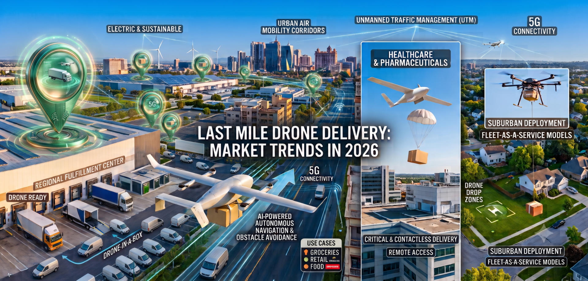
Global forecasts, regional momentum, and the location intelligence layer that makes it work,
market size, operator moves, regulation, India’s trajectory, and how Potters Maps fits in.
2026 is the year drone delivery crossed from novelty into infrastructure. Regulators shifted from waiver-based approvals to standardized frameworks, operators moved from pilot pods to permanent hubs, and the volume math started to work at retail scale. According to Fortune Business Insights, the global drone delivery service market is valued at USD 5.06 billion in 2026 and is on track to reach USD 20.98 billion by 2034 at a CAGR of 19.45 percent. MarketsandMarkets places the delivery drone segment at USD 2.88 billion in 2026 and USD 7.65 billion by 2031 at 21.6 percent CAGR, with volumes projected to grow from 114,939 units in 2026 to 292,544 by 2031.
Zooming in on the last-mile segment, Fact.MR estimates it at USD 0.7 billion in 2026 heading to USD 7.7 billion by 2036 at 27.3 percent CAGR, and Global Market Insights reports drones already hold 49 percent of the autonomous last-mile delivery market by platform. Delivery is now the largest and fastest-growing revenue engine in the drone economy.
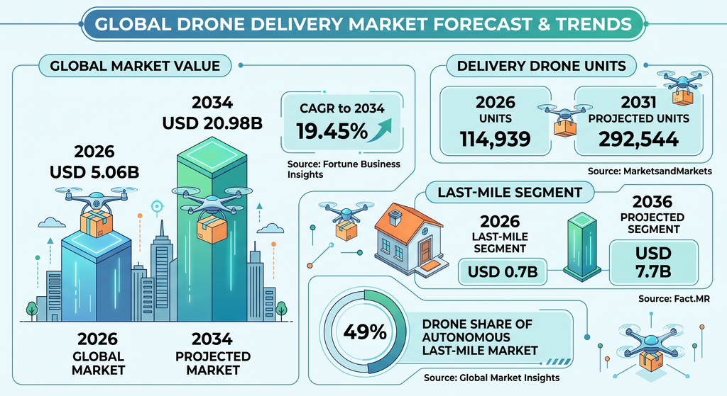
Figure 1. Global drone delivery market at a glance, 2026
| Metric | Value | Source |
|---|---|---|
| Global drone delivery service market, 2026 | USD 5.06B | Fortune Business Insights |
| Same market, 2034 projected | USD 20.98B | Fortune Business Insights |
| CAGR to 2034 | 19.45% | Fortune Business Insights |
| Delivery drone units, 2026 | 114,939 | MarketsandMarkets |
| Delivery drone units, 2031 projected | 292,544 | MarketsandMarkets |
| Last-mile drone segment, 2026 | USD 0.7B | Fact.MR |
| Last-mile drone segment, 2036 projected | USD 7.7B | Fact.MR |
| Drone share of autonomous last-mile market | 49% | Global Market Insights |
The Regional Picture
North America remains the clear leader, holding approximately 41.8 percent of the delivery drones market in 2026 according to Coherent Market Insights. The lead is anchored by the FAA’s move toward Part 108, more than 30 Part 135 air-carrier certificates now issued to drone operators, and dense operational footprints from Amazon, Wing, and Zipline. The Middle East is projected to grow fastest globally at 27.8 percent CAGR through 2031, per MarketsandMarkets, backed by smart-city investment, favorable regulation, and expanding healthcare logistics use cases. Asia-Pacific runs on scale: China alone is forecast to grow at 29.4 percent CAGR through 2036 (Fact.MR), while India and Southeast Asia expand through public and private BVLOS pilots.
On the operator side, 2026 has been a coming-out year. Amazon announced a sixfold expansion of Prime Air to nearly 500 US cities and towns by year-end, targeting 30 million customer households. Alphabet’s Wing crossed one million commercial deliveries and, with Walmart, plans to operate from over 270 stores by 2027, reaching more than 40 million Americans. Zipline has logged two million deliveries across four continents and, following its Uber partnership, is targeting one million deliveries per day by late 2029. DoorDash Air received FAA certification in July and launches commercial operations in fall 2026.
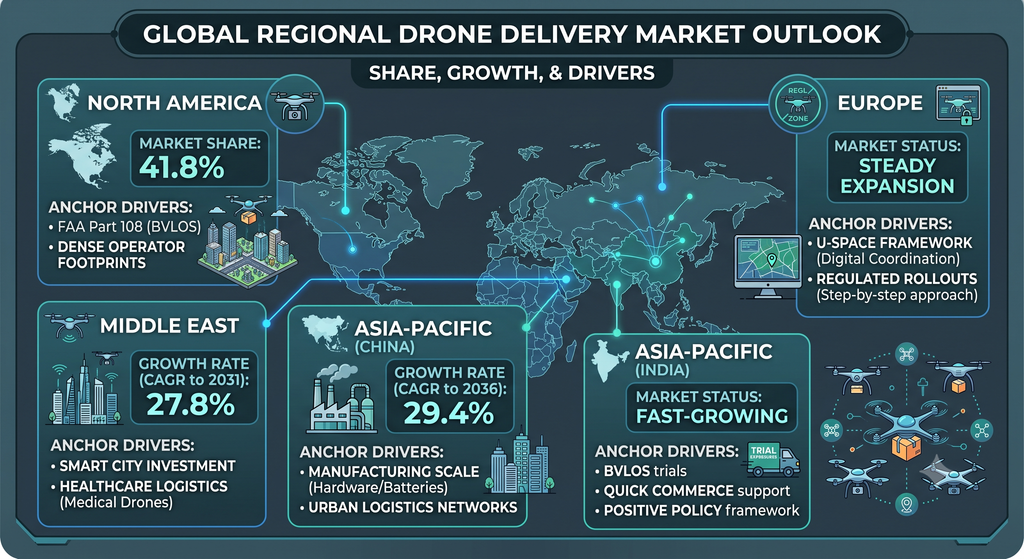
Figure 2. Regional drone delivery market snapshot, 2026
| Region | Market Share / Growth Rate | Anchor Driver |
|---|---|---|
| North America | 41.8% share | FAA Part 108, dense operator footprints |
| Middle East | 27.8% CAGR through 2031 | Smart city investment, healthcare logistics |
| Asia-Pacific (China) | 29.4% CAGR through 2036 | Manufacturing scale, urban logistics |
| Asia-Pacific (India) | Fast-growing | BVLOS trials, quick commerce, policy support |
| Europe | Steady expansion | U-Space framework, regulated rollouts |
What Is Changing in 2026
BVLOS moves from waiver to rule. The FAA’s proposed Part 108 framework replaces case-by-case waivers for beyond-visual-line-of-sight operations with a standardized regulatory pathway. According to Robotomated, final rules are expected in 2026 to 2027 and will dramatically simplify multi-market expansion. The EU’s U-Space framework is doing analogous work in Europe.
Tethered delivery replaces the 13-foot drop. Wing and Zipline’s Platform 2 have long used retractable tethers to lower packages gently, enabling deliveries to apartments, offices, and sites without clear landing pads. Amazon is now trialing its own tether mechanism, expanding the range of goods that qualify for drone delivery to perishables and fragile items.
Air corridors, UTM, and payload concentration. Unmanned Traffic Management systems, from private USS providers integrated with FAA LAANC to India’s Skye UTM handling 4,000 flights per hour, are stitching together dedicated drone corridors above congested airspace. Detect-and-avoid and Remote ID are now baseline. On the airframe side, multi-rotor drones hold 48.7 percent share in 2026 (Coherent) and the 5 to 25 kg payload class holds 37 percent, the sweet spot for grocery, pharmacy, restaurant, and light retail.
Drone delivery is no longer a bet on the aircraft. It is a bet on the operational fabric around it: BVLOS regulation, UTM software, and ground-truth location data.
India’s Distinctive Path
India represents one of the most policy-driven drone delivery ecosystems in the world. The Drone Rules 2021, the PLI scheme, GST reduction to 5 percent, and the Drone Shakti programme have collectively lowered the cost of entry. Twenty consortia including Swiggy, Dunzo, and Zomato hold BVLOS test approvals, and startups such as Skye Air, Garuda Aerospace, TechEagle, and ideaForge have moved from trials to routine commercial deliveries. Skye Air alone has crossed 3.6 million autonomous deliveries and completed India’s longest BVLOS medical flight, a 104-kilometer run in West Bengal that cut delivery time by 80 percent. The India last-mile delivery segment is projected to reach INR 1.8 trillion, with drone corridors, cold-chain integration, and rural pharmacy delivery the fastest-growing use cases. India is positioned to be the second-largest drone delivery market by volume behind China by the end of the decade.
The Location Intelligence Layer: Where Potters Maps Fits
A drone is only as useful as the map it flies against. Every dispatch decision, route computation, landing-zone approval, and last-hundred-meter descent depends on accurate POIs, precise geocoding, ground-truth imagery, and airspace-aware routing. This is where Potters Maps, part of Potters Technologies, has quietly built one of the most operationally relevant stacks for drone delivery in South and Southeast Asia.
The Product Suite
Places Database. Over 70 million Points of Interest globally, enriched with names, addresses, categories, opening hours, and custom attributes. For drone operators, this becomes the authoritative source for identifying dispatch origins (dark stores, pharmacies, restaurants) and delivery destinations (residential complexes, offices, hospitals) with the metadata needed to plan payload class, timing, and permitted airspace.
Imagery Platform. Over three million street-level images accessed through the Imagery Platform, with automatic detection surfacing landing zones, obstructions, signage, and traffic signs. A tethered drone hovering over an unfamiliar apartment complex needs exactly this kind of ground-truth visual context to lower a package safely, and Potters Maps supplies it as an API rather than a manual survey.
Naksha Data Collection App. A rewards-based crowdsourcing app that pays contributors to submit verified on-ground data such as new POIs, address corrections, storefront photos, and route conditions. In markets where dispatch and drop-off geographies change faster than centralized surveys can track, Naksha keeps the drone-ready map current.
Custom APIs. The Custom APIs suite includes the POI Extraction API (OCR plus large language models to structure POI data from storefront photos), the Location Image API (visual context for delivery destinations), the Blurring API (GDPR-compliant face and licence-plate obfuscation), and endpoints for routing, address parsing, POI search, route planning, and traffic sign detection. All translate directly into inputs that drone dispatch, UTM platforms, and last-mile fulfillment stacks need.
AI and ML Models. Proprietary models trained on Indian and regional geography, address structures, signage, and traffic patterns power the detection pipelines and API layer. As drone operators expand into tier-two and tier-three cities, they will increasingly depend on models trained on those exact conditions, not on data collected in California or Berlin.
Why The Fit Matters
The strategic gap in drone delivery is not aviation, it is addressing. Drones can fly the corridor; the harder problem is deciding which precise coordinates constitute a valid landing zone at a particular building, at a particular hour, given local signage and obstruction patterns. Potters Maps has assembled exactly the stack that answers that question at scale, and its day-by-day improvement in POI freshness, imagery coverage, and API reliability positions it as a natural infrastructure partner for drone operators, quick-commerce platforms, and UTM systems defining the next phase of the market.
Outlook 2026 to 2030
By 2030, drone delivery is expected to be a mainstream logistics channel handling over one billion packages annually, absorbing 10 to 20 percent of last-mile deliveries for lightweight items. Amazon’s stated aim of 500 million packages a year by drone by the end of the decade, the Wing-Walmart 60-million-household target, and the Uber-Zipline one-million-daily-deliveries goal are ambitious, but 2026 is the first year the numbers behind them look structurally achievable. Regulatory scaffolding is in place, tethered delivery has removed a major operational constraint, and the underlying location intelligence stack has matured enough to automate dispatch, routing, and landing end to end.
The strategic implication is that drone delivery is no longer a bet on the aircraft. It is a bet on the operational fabric around it: BVLOS regulation, UTM software, and the ground-truth location data that tells a drone exactly where to fly and land. Platforms like Potters Maps that have quietly built region-native versions of that data layer are positioned to become the invisible infrastructure determining which drone delivery programs scale and which stall.
Sources and Credits
- Fortune Business Insights. Drone Delivery Service Market Report 2034. fortunebusinessinsights.com
- MarketsandMarkets. Delivery Drone Market 2026-2031. marketsandmarkets.com
- Fact.MR. Last Mile Drone Delivery Market Analysis to 2036. factmr.com
- Global Market Insights. Autonomous Last Mile Delivery Market. gminsights.com
- Coherent Market Insights. Delivery Drones Market Report. coherentmarketinsights.com
- CNBC. Amazon Prime Air expansion coverage, August 2026. cnbc.com
- Digital Commerce 360. Drone delivery competitive landscape 2026. digitalcommerce360.com
- Robotomated. Drone Delivery Market 2026 analysis. robotomated.com
- Drone Intelligence. India Drone Delivery Market 2026 Forecast. droneintelligence.ai
- Value for Startups. Skye Air Mobility Investor Report 2026. valueforstartups.in
- Potters Maps. Official website. pottersmaps.com
Note:
Data compiled from public market research reports, operator press disclosures, and regulatory filings. Where estimates differ across sources, the most recently published figure has been preferred. Figures rounded for clarity. All financial values are expressed in United States dollars unless otherwise noted.