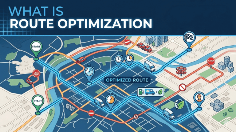
Every delivery driver, field service technician, sales representative, and ride-hailing vehicle moving through a city is solving a version of the same problem: given a list of places to visit and limited time, what is the best order and path for the journey? This problem, known as route optimization, sits at the centre of modern logistics economics. Solve it well and a fleet of 100 vehicles can do the work of 120. Solve it poorly and the same fleet wastes fuel, misses time windows, and disappoints customers. Understanding what route optimization is, how it works, and what it depends on is essential for anyone running operations that move through the physical world.
Route optimization is the process of determining the most efficient sequence and path for a vehicle or set of vehicles to follow when visiting multiple destinations. The objective is typically to minimize a cost function such as total time, distance, or fuel consumption, while respecting a wide range of operational constraints. Constraints can include vehicle capacity, driver shift hours, customer time windows, road restrictions, vehicle type compatibility with certain stops, and required service durations at each location.
According to research published by INFORMS, route optimization is a foundational problem in operations research and is studied under the broader category of vehicle routing problems, or VRP. What distinguishes practical route optimization from textbook VRP is the volume of real-world constraints and the need to produce solutions in seconds rather than hours.
The mathematical core of route optimization is computationally hard. The classical Travelling Salesman Problem, in which a single traveller must visit every city once and return home, becomes intractable by brute force once the number of cities grows beyond about 15. A delivery vehicle serving 80 stops faces a search space larger than the number of atoms in the observable universe.
As the Society for Industrial and Applied Mathematics has documented, modern route optimization relies on heuristic and metaheuristic algorithms that produce near-optimal solutions in practical time. Approaches such as simulated annealing, tabu search, genetic algorithms, and large-neighbourhood search are routinely combined with constraint programming to handle real fleet requirements. The output is rarely the mathematically optimal route, but it is consistently close enough that the savings dwarf the marginal benefit of further computation.
A route optimization algorithm is only as good as the data flowing into it. The inputs typically include the list of stops with their coordinates, time windows, and service durations, the available vehicles with their capacities and shift schedules, the road network with current and predicted traffic, the depot locations, and operational rules unique to the business. If any input is wrong, the algorithm produces a route that looks optimal on paper but fails in execution.
The single most important input is the precise location of each stop. A street address alone is not enough. The algorithm needs a latitude and longitude corresponding to the actual point where the driver will stop. Imprecise coordinates send drivers to the wrong side of a divided road, the wrong end of a long building, or in extreme cases, an entirely different premises. Each such error introduces minutes of wasted time that cascade across the rest of the route.
Because every routing decision is ultimately a location decision, route optimization depends on a high-quality location intelligence layer underneath it. The Potters Maps Places API suite is built specifically to provide this foundation. It combines geocoding, reverse geocoding, autocomplete, search, and address validation into a single integrated location stack that route optimization engines can consume directly.
The value of consolidating these capabilities into one suite is consistency. When the address of a stop is captured at order intake, geocoded at routing time, tracked during execution, and reverse-geocoded for customer notification, all four operations need to refer to the same underlying place. A fragmented stack, in which different APIs disagree about where a location is, produces inconsistencies no routing algorithm can fix downstream. The Places API suite avoids this fragmentation by serving every step of the location pipeline from one consistent dataset, backed by the Potters Maps database of over 70 million points of interest across multiple countries and territories.
The cheapest moment to catch a location error is before it enters the routing pipeline. If a customer enters a malformed address at checkout, every downstream system inherits that error. By the time the failure surfaces at the doorstep, the cost has already been spent.
The Potters Maps Autocomplete API addresses this at the point of entry. As a customer types, the API surfaces validated address candidates from the underlying places database, allowing the user to select rather than type the full address. This reduces typos, missing components, and ambiguity. For applications ingesting addresses through other channels, such as bulk imports or partner integrations, the Potters Maps Address Validation API performs the same cleanup retrospectively, parsing and standardizing addresses into a structured, deliverable format before they enter the routing queue.
According to a study by the National Retail Federation, poor address data is one of the most common contributors to failed first-attempt deliveries. Address quality interventions at intake are therefore a direct route optimization input.
Once addresses are clean, the routing algorithm needs each one converted into coordinates with the precision required to support real-world navigation. The Potters Maps Forward Geocoding API performs this conversion, returning coordinates that correspond to actual delivery points rather than approximated street centroids. This precision matters because route optimization uses the coordinates to calculate travel times between stops, and a coordinate placed even 100 metres away from the true delivery point can shift the calculated travel time by several minutes. Across an 80-stop route, the cumulative drift can render the entire schedule unreliable.
The geocoder also enriches each stop with attributes drawn from the underlying places database. Knowing a stop is a high-rise commercial building rather than a single-family home, or that a venue has a dedicated loading area, allows the routing logic to assign appropriate service durations and approach paths matching each location’s physical characteristics.
A planned route is a starting point, not a finished product. Once a driver departs, conditions change: traffic worsens, a stop takes longer than expected, a customer reschedules, a road closes. Effective route optimization is therefore not just a planning exercise but a continuous reoptimization process throughout the day.
The Potters Maps Reverse Geocoding API supports this real-time layer by converting the continuous stream of GPS pings from driver devices into readable address updates that dispatchers and customers can interpret. When a vehicle is 200 metres from a stop, the dispatcher sees a specific street name rather than a raw coordinate. The Potters Maps Search API complements this by allowing drivers and dispatchers to locate nearby points of interest in real time, whether to find alternate parking, a fuel station, or a customer pickup location adjacent to the planned stop.
Even after a vehicle arrives at the correct coordinate, the driver still has to identify the exact storefront, gate, or entrance in front of them. In dense commercial streets or mixed-use buildings, this final visual identification is where many otherwise-perfect routes lose time. The Potters Maps Location Image API closes this gap by providing imagery associated with each point of interest, letting drivers visually confirm the destination before leaving the vehicle. The Potters Maps POI Extraction API supports the continuous freshness of this imagery and the underlying place records by using OCR and language models to extract structured information from storefront images captured in the field.
Together, these capabilities mean a route optimized on accurate coordinates is also delivered against accurate visual context, reducing the gap between the optimal route on paper and the realized route on the ground.
Route optimization is one of the most consequential and most data-dependent operations in modern logistics. The algorithms themselves are sophisticated, but their output quality is bounded almost entirely by the quality of the location data they consume. Imprecise addresses produce imprecise routes. Stale place records produce wasted driver time. Fragmented location stacks produce inconsistencies that no amount of algorithmic refinement can repair.
A unified location intelligence layer, such as the Potters Maps Places API and Custom API suite, provides the consistent, accurate, continuously refreshed foundation that route optimization engines need to operate at their full potential. From address autocomplete at intake through validation, forward and reverse geocoding, search, and visual confirmation in the field, the suite covers every stage of the routing lifecycle. Businesses investing in route optimization should think of the underlying location layer not as a separate tooling choice but as the core determinant of how well their optimization will perform in the real world.
Newsletter signup. Travel with confidence accurate road and traffic information.
© 2026 Potters Maps. All Rights Reserved.